Map editor video coming soon
Within the next week I plan to upload a video demonstration of the Feudal Wars map editor. And based on feedback from that video, I will release an interactive prototype. It only makes sense to release the map editor before the game. After all, I need to build the map editor first almost out of necessity, since other aspects of the game rely on it.
The main goal for the map editor can be expressed with the following analogy:
Photoshop is to images as my map editor will be to 2d games.
I say 2d games and not 2d RTS games, because, eventually, the map editor is going to be versatile enough to outright build separate games not limited to the RTS genre. Of course that versatility won’t be there at initial release. But much later on, once I’ve finished the custom game creator components, complete with triggering mechanisms, messaging/cinematics, objectives and all the tools people need to create their own custom games.
It’s a bit audacious, I know, but I think it can be accomplished with all the tools available in Canvas and webGl.
One of the big features of the map editor is zero grid restrictions on walkable terrain. In typical 2d map editors, the size of ground tiles is restricted to a grid system. The FW editor does away with that since walkable terrain elements are not represented in the grid and can therefore be any shape/dimension.
This allows for a lot of freedom in how tiles can overlap and blend with each other:
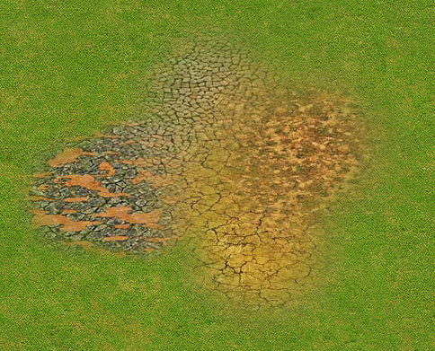
Note the shape of the texture is that of a circle. Neat huh? I can get away with ground textures not being restricted to the grid because I have independent grids for pathfinding, rather than a single central grid for tiles/game objects.
Unwalkable terrain elements, such as water and cliffs, will be restricted to a grid. i.e when you place a water texture, it has to be proportionate with the node size of the grid and needs to snap to the grid. In essence the water area placements need to be modular, because the pathfinding system is modular.
Another big feature of the map editor is the ability to upload custom game assets (including ground textures, terrain objects and buildings). This is something I had planned to add from the very beginning. I want to give people the tool to create an implement their own artwork into custom maps/games. This is a feature anyone with basic photoshop skills can take advantage of. What sort of of content are people allowed to upload and with what spec?
Here’s a rough idea:
- Buildings and terrain objects (such as trees, cliffs, etc) need to be in the dimetric perspective (the 3D camera is 30/45). This is optional but your assets will look really stupid if they are not in the correct perspective. I plan on writing detailed instructions for creating artwork in the correct perspective.
- Ground textures can be no less than 1000 pixels wide and 800 in height and no greater than 2500 wide and 1500 in height.
Why so big, you ask? Well, when you load a texture into the map it starts out in a compressed format, such as a JPG or PNG. The second you try to edit that texture in the map editor by, for example, blending another texture on top of it, it converts to an uncompressed format: a bitmap.The HTML5 canvas can easily manipulate bitmap data (cropping, blending, changing hue, etc), but it can’t touch compressed formats. This is why I make the tiles so big. Converting to a BMP is a hefty operation, especially for a browser. A few larger images is much better than having oodles of smaller images because fewer images means fewer conversion operations, which ultimately means smoother performance.
So yeah, that’s a little of what I have planned for the map editor. Stay tuned for the video demonstration!